
The models exist. Making them work as one defensible decision system is the problem.
Integrated water-resources modeling, built so that provenance, uncertainty, and assumptions survive all the way to the decision.
Integration is the constraint, not modeling capacity
Water-resources management is rarely limited by the absence of a model, but by how badly independently built models, datasets, scales, and assumptions combine into something a decision can rest on.
- Fragmented ownership
- Models are built independently by the specialists who understand them best, then asked to interoperate through spreadsheets and file handoffs that preserve none of their structure.
- Incompatible semantics
- The same term means different things across disciplines. Demand, storage, loss, and reuse are each specific to whoever defined them, and those definitions rarely travel with the numbers.
- Scale mismatch
- Daily against monthly, reach against basin, parcel against region. Reconciling resolution is treated as a preprocessing chore rather than an analytical decision.
- Flattened uncertainty
- Ranges collapse to point values at every boundary crossing. By the time analysis reaches a decision-maker, the confidence quantified upstream has been quietly discarded.
- Lost provenance
- Six months after a recommendation, no one can reconstruct which assumption, which dataset version, or which model run produced a specific number.
- Integration latency
- When re-running a connected analysis costs weeks, teams ask fewer questions. The real loss is not the delay but the analyses never attempted and the dependencies never found.
Changed information does not propagate through connected systems, so knowledge gaps and unrecognized dependencies stay hidden until after the decision is made.
Shared foundations around independently owned science
The answer is not one model to replace the others. It is a shared foundation that specialist models can connect through while their authors retain scientific control.
- Shared semantics
- Common definitions and versioned data contracts, so a quantity means the same thing on both sides of a handoff.
- Retained ownership
- Domain specialists keep authorship and scientific control of their own models. Integration is a contract to meet, not a takeover.
- Explicit uncertainty
- Uncertainty crosses boundaries as a first-class property rather than collapsing into a single number at each step.
- Provenance and lineage
- Every output traces back to its inputs, assumptions, source documentation, and the model version that produced it.
- Versioned evidence
- Planning versions are preserved rather than overwritten, so past decisions stay reconstructible in the context that produced them.
- Auditable workflows
- The path from evidence to recommendation is inspectable by someone who was not in the room when it was built.
Source to sea, and the systems in between
Seven domains, ordered by present depth rather than career chronology. The integration argument only carries weight if the underlying modeling is real.
Water Demand, Supply, and Long-Range Scenario Modeling
Multi-decade demand and supply planning for arid environments, from loose concepts to monthly operational detail.
Riverine Hydraulics and Flood Risk
Hydraulic modeling and floodplain analysis for flood-risk, infrastructure, and regulatory studies.
Estuarine and Coastal Hydrodynamics
Circulation, salinity, transport, and dissolved-oxygen dynamics in frictional coastal systems.
Watershed and Groundwater Analysis
Watershed integration, groundwater resources, and managed aquifer recharge pre-planning.
Geospatial Analysis, Remote Sensing, and Machine Learning
Deep-learning feature extraction, multi-decadal change detection, and spatial data infrastructure.
Scientific Software and Decision-Support Systems
Reproducible analytical software, data pipelines, and auditable decision-support applications.
Field Measurement and Survey Design
Campaign design, instrument placement, and hydrographic survey in difficult coastal environments.
Evidence, not adjectives
Four projects that show the range: multi-decade utility planning in an arid region, landscape-scale machine learning, a tidal-cycle field campaign, and four years of coastal marsh research.
Regional Water Demand and Supply Planning Model
A versioned node-based demand and supply planning model spanning 2024–2080, informing water infrastructure investment and phasing.
- 2024–2080
- 10–20
- Sole developer
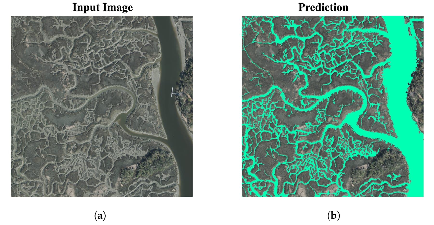
Deep-Learning Segmentation of Tidal Creek Networks
An attention-based Dense U-Net that segments tidal creek networks from 0.5 m aerial imagery at F1 = 0.98.
- 255 km²
- 0.5 m
- 0.98
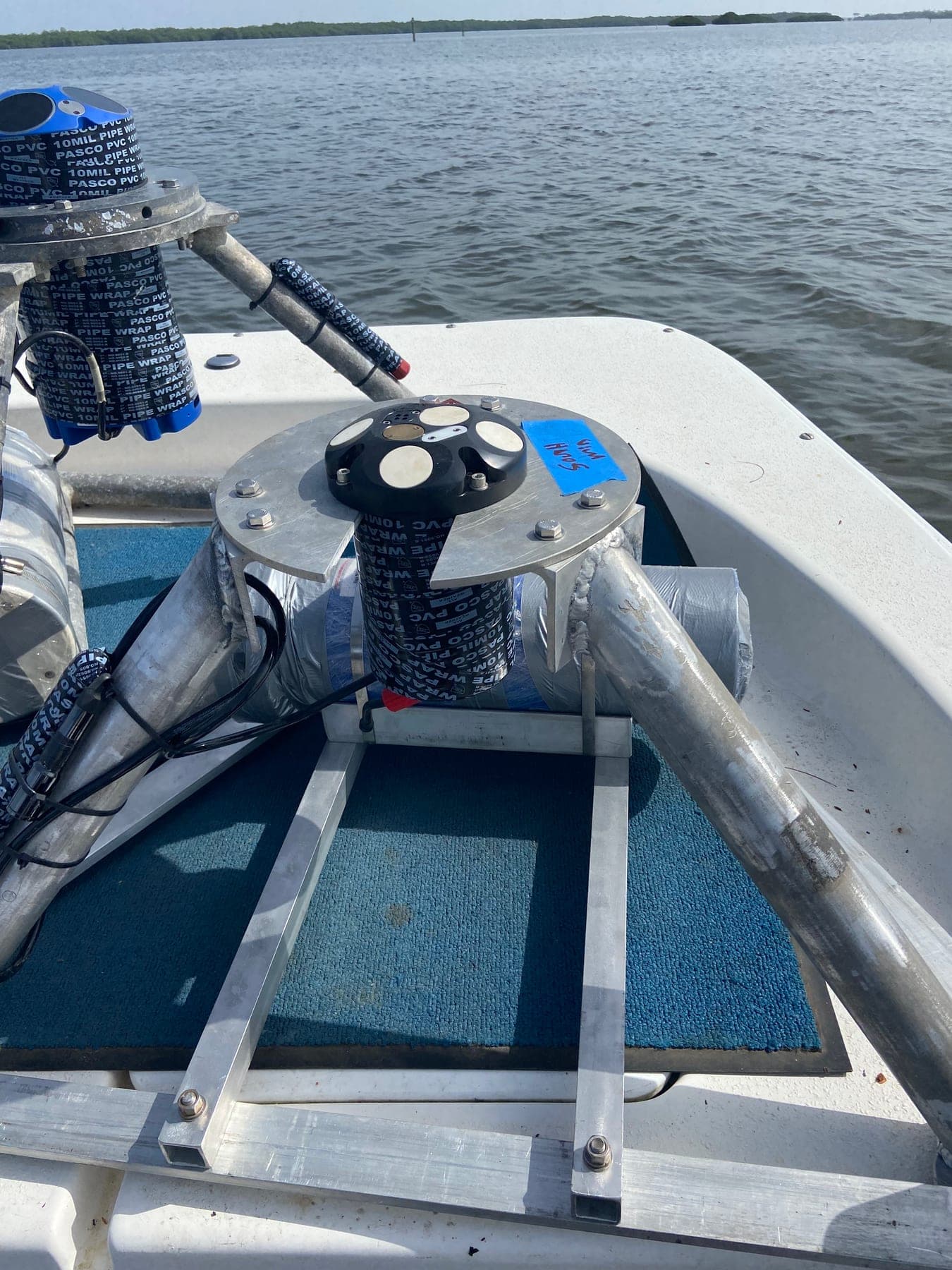
Estuarine Circulation Field Campaign, Matlacha Pass
Shipboard and moored velocity profiling across ~20-hour tidal cycles to explain ecological risk and fish-kill events.
- ~20 h cycles
- ADCP · CTD
Coastal Marsh Dynamics and Faunal Engineering
Multi-year field and remote-sensing research on marsh evolution, published in PNAS and Nature Communications.
- 4 years
- PNAS · Nat. Commun.
Peer-reviewed, and cited
The integration argument is made by someone who has published the underlying science, not only written about it.
13
419
11
11
Most recent
Morphodynamics of anabranching structures in the Peruvian Amazon River
Earth Surface Processes and Landforms · 2025
Identifying critical source areas of non-point source pollution to enhance water quality: Integrated SWAT modeling and multi-variable statistical analysis
Water Research · 2024
Hydrogeomorphology of the origin of the Amazon River, the confluence between the Marañón and Ucayali rivers
Earth Surface Processes and Landforms · 2024
Selected venues
- Proceedings of the National Academy of Sciences
- Nature Communications
- Water Research
- Water Resources Research
- Journal of Geophysical Research: Oceans
- Advances in Water Resources
- Remote Sensing
Two useful conversations
Whether that is a joint proposal, a model that needs to talk to three others, or a long-range planning problem that has outgrown its spreadsheet — say which and the reply will be more useful.
Start a conversation- Research collaboration
- Joint proposals, co-authored work, shared datasets, model interoperability, or a program that needs an integration layer. Also the right choice for institutions weighing how this capability might sit alongside existing teams.
- Technical engagement
- Water demand and supply modeling, long-range scenario planning, hydraulic and coastal analysis, geospatial and machine-learning work, or decision-support software for utilities, agencies, and engineering firms.